Randonnée Course à pied The Municipal District of Cahir — Cashel - The Millenium Stone Loop - Photo
 mlmoroneybb
mlmoroneybb

Utilisateur

© OpenStreetMap contributors
Longueur
Longueur
9,4 km
Altitude max
Altitude max
312 m
Dénivelé positif
Dénivelé positif
226 m
Km-Effort
Km-Effort  
12,4 km
Altitude min
Altitude min
174 m
Dénivelé négatif
Dénivelé négatif
227 m
Boucle
Boucle
Oui
Date de création :
2014-12-10 00:00:00.0
Dernière modification :
2014-12-10 00:00:00.0

(0 Avis)

Course à pied
Course à pied
2h00
Difficulté : Moyen

Scannez ce code QR pour ouvrir la randonnée dans l'application SityTrail

Application GPS de randonnée GRATUITE

Logo SityTrail SityTrail

IGN / Instituts géographiques

Télécharger SityTrail sur l'App Store Télécharger SityTrail sur Google Play

Logo SityTrail SityTrail World

Le monde est à vous

Télécharger SityTrail sur l'App Store Télécharger SityTrail sur Google Play Télécharger SityTrail sur Huawei AppGallery

À propos

Randonnée Course à pied de 9,4 km à découvrir à Inconnu, County Tipperary, The Municipal District of Cahir — Cashel. Cette randonnée est proposée par mlmoroneybb.

Description

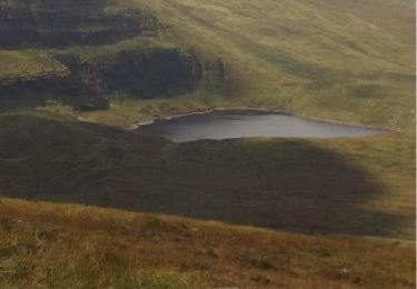
A-B. From the mapboard in the green area climb onto the road and go to the Christ the King statue. Follow the blue arrow and enter the forestry at the barrier. Note that you are also following red arrows which are for the shorter Rock an Thorabh Loop. After 50m you reach a Y-junction where the red loop continues straight – but you veer right and downhill following the blue arrow

Profil altimétrique

Localisation

Pays :
Irlande
Région :
Inconnu
Département/Province :
County Tipperary
Commune :
The Municipal District of Cahir — Cashel
Localité :
Clonbeg
Départ:(Dec)
Départ:(UTM)
556564 ; 5809165 (29U) N.

Randonnées à proximité

Randonnée Marche The Municipal District of Cahir — Cashel - l diheen - Photo
Marche
mlmoroneybb

Marche

Difficile
The Municipal District of Cahir — Cashel, Inconnu, County Tipperary, Irlande
16,3 km | 32 km-effort
5h 46min
Oui
Randonnée Marche The Municipal District of Cahir — Cashel - Galtees - Lake Muskry Circuit - Photo
Marche
johnkeating

Marche

Très facile
The Municipal District of Cahir — Cashel, Inconnu, County Tipperary, Irlande
10,1 km | 18,2 km-effort
3h 10min
Non
Randonnée Course à pied The Municipal District of Cahir — Cashel - Bianconi Loop - Photo
Course à pied
mlmoroneybb

Course à pied

Facile
The Municipal District of Cahir — Cashel, Inconnu, County Tipperary, Irlande
3,8 km | 5,3 km-effort
2h 0min
Oui
Randonnée Course à pied The Municipal District of Cahir — Cashel - Ballinacourty Loop - Photo
Course à pied
mlmoroneybb

Course à pied

Moyen
The Municipal District of Cahir — Cashel, Inconnu, County Tipperary, Irlande
8,2 km | 10,9 km-effort
2h 0min
Oui
Randonnée Marche The Municipal District of Cahir — Cashel - Slievenamuck Walking Marathon Sunday March 24th 2013 - Photo
Marche
mlmoroneybb

Marche

Difficile
The Municipal District of Cahir — Cashel, Inconnu, County Tipperary, Irlande
42 km | 56 km-effort
11h 36min
Non
Randonnée Marche The Municipal District of Cahir — Cashel - Galtee Walking Club Marathon - Photo
Marche
mlmoroneybb

Marche

Difficile
The Municipal District of Cahir — Cashel, Inconnu, County Tipperary, Irlande
41 km | 54 km-effort
11h 22min
Oui
Randonnée Marche The Municipal District of Cahir — Cashel - lisvarrinane new - Photo
Marche
mlmoroneybb

Marche

Facile
The Municipal District of Cahir — Cashel, Inconnu, County Tipperary, Irlande
4,6 km | 6 km-effort
1h 17min
Oui
Randonnée Marche The Municipal District of Cahir — Cashel - Winter B 2012 - Photo
Marche
mlmoroneybb

Marche

Moyen
The Municipal District of Cahir — Cashel, Inconnu, County Tipperary, Irlande
12,7 km | 17,3 km-effort
Inconnu
Oui
Randonnée Marche The Municipal District of Cahir — Cashel - Rock an Torabh Walk - Photo
Marche
mlmoroneybb

Marche

Moyen
The Municipal District of Cahir — Cashel, Inconnu, County Tipperary, Irlande
8,1 km | 10,7 km-effort
2h 18min
Oui


Fermer
Mes abonnements